27.08.2024 17:07
Ride
-
Dystans
41.05 km
-
Średnia prędkość
15.89 km/h
-
Maksymalna prędkość
46.76 km/h
-
Czas ruchu
02:35
-
Całkowity czas
02:50
-
Najniższa wysokość
233.2 m
-
Najwyższa wysokość
284.4 m
-
Suma przewyższeń
178 m
-
Kalorie
1419
-
Kwadraty
17
-
Osiągnięcia
7
Zdjęcia na trasie
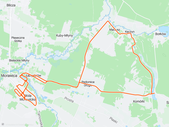
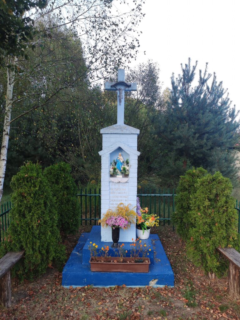
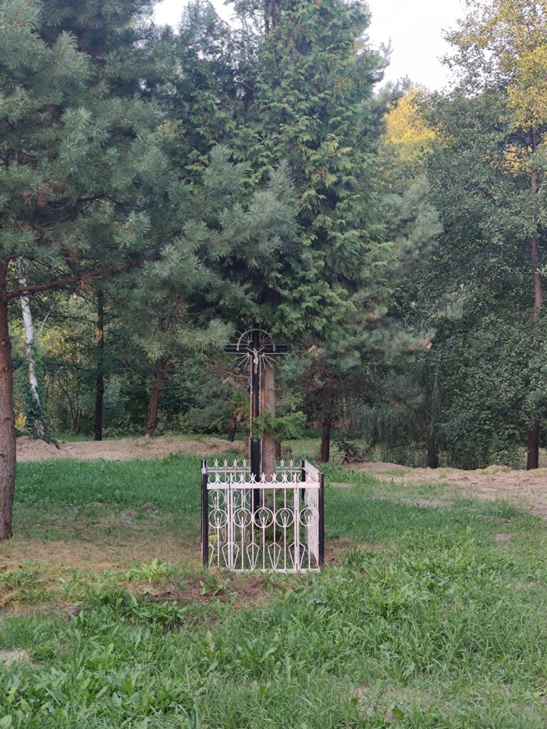
Trasa
| Podział | Dystans (km) | Czas trwania (min) | Różnica wysokości (m) | Średnia prędkość (m/s) |
|---|---|---|---|---|
| 1 | 1.03 | 5:67 | -10 | 3.45 |
| 2 | 0.97 | 3:93 | -0.2 | 4.12 |
| 3 | 1.00 | 4:1 | 2 | 4.06 |
| 4 | 1.00 | 3:53 | 3.4 | 4.74 |
| 5 | 1.01 | 3:65 | 6.6 | 4.62 |
| 6 | 0.98 | 3:52 | 8.2 | 4.66 |
| 7 | 1.02 | 5:67 | 11.6 | 3.99 |
| 8 | 0.99 | 3:13 | -0.8 | 5.26 |
| 9 | 0.99 | 3:13 | 6 | 5.29 |
| 10 | 1.01 | 3:5 | 7.4 | 4.79 |
| 11 | 0.98 | 3:1 | -14.2 | 5.29 |
| 12 | 1.00 | 5:88 | -10.6 | 4.4 |
| 13 | 1.01 | 5:97 | -1.8 | 2.82 |
| 14 | 0.99 | 7:48 | -4.4 | 2.55 |
| 15 | 1.00 | 9:35 | -1.2 | 2.18 |
| 16 | 1.01 | 4:2 | -1.2 | 4.81 |
| 17 | 1.00 | 5:12 | -0.8 | 4.62 |
| 18 | 1.01 | 4:15 | 3 | 4.94 |
| 19 | 0.98 | 4:58 | 4 | 4.86 |
| 20 | 1.00 | 2:62 | -10.4 | 6.37 |
| 21 | 1.03 | 2:92 | 2.8 | 5.9 |
| 22 | 0.98 | 4:22 | 9.8 | 3.87 |
| 23 | 1.00 | 3:33 | -4 | 5 |
| 24 | 1.00 | 2:43 | -9.2 | 6.85 |
| 25 | 1.00 | 3 | 3.2 | 5.56 |
| 26 | 1.01 | 3:12 | -6.4 | 5.39 |
| 27 | 1.00 | 3:77 | -5.2 | 4.42 |
| 28 | 1.00 | 12:47 | -0.4 | 3.61 |
| 29 | 1.00 | 4:15 | -0.4 | 4.04 |
| 30 | 1.01 | 5:65 | 4 | 3.75 |
| 31 | 0.96 | 3:07 | 0.8 | 5.24 |
| 32 | 1.00 | 2:45 | -5 | 6.8 |
| 33 | 1.06 | 2:88 | 0.4 | 6.11 |
| 34 | 0.95 | 2:6 | 0.2 | 6.11 |
| 35 | 1.01 | 2:9 | -0.2 | 5.78 |
| 36 | 0.99 | 2:67 | -0.4 | 6.18 |
| 37 | 1.04 | 2:83 | 4.4 | 6.09 |
| 38 | 0.99 | 3:62 | 3 | 4.58 |
| 39 | 0.99 | 3:08 | 1 | 5.37 |
| 40 | 1.00 | 3:15 | -6.6 | 5.26 |
| 41 | 0.98 | 2:93 | 6.8 | 5.55 |
| 42 | 0.06 | 0:58 | 1.4 | 2.1 |
Miejscowości
- województwo świętokrzyskie
- powiat kielecki
- gmina Daleszyce
- Marzysz
- Komórki
- Szczecno
- gmina Pierzchnica
- Skrzelczyce
- gmina Morawica
- Radomice
- Łabędziów
- Morawica
- Wola Morawicka
- gmina Daleszyce
- powiat kielecki
Strava segmenty
| Nazwa | Czas trwania (s) | Czas w ruchu (s) | Odległość (m) | Średnie nachylenie (%) | Maksymalne nachylenie (%) | Wysokość maks. | Wysokość min. |
|---|---|---|---|---|---|---|---|
| [R] Morawica - Łabędziów | 275 | 275 | 1319.8 | 0.2 | 2.9 | 213 | 208.2 |
| Łabędziów-Komórki podjazd | 1648 | 1559 | 7345.1 | 0.6 | 5.4 | 272.4 | 229 |
| Radomice Las | 434 | 434 | 1986.1 | 0.7 | 7.2 | 249.8 | 236 |
| Radomice Drugie / Zagórze, Główna (św. Antoniego - Skok) | 142 | 142 | 760 | -0.1 | 0.9 | 260.9 | 260.2 |
| Przez Komórki | 653 | 653 | 3482.6 | -0.2 | 2.5 | 276 | 250.6 |
| Marzysz pierwsza hopka | 136 | 134 | 450.9 | 1.8 | 4.2 | 249.2 | 240.7 |
| Marzysz Pierwszy - Zjazd do Młynów | 228 | 226 | 714.7 | 0.6 | 6.1 | 252.6 | 241.4 |
| Marzysz Pierwszy - Marzysz Drugi | 371 | 369 | 1647.4 | -0.2 | 7 | 252.6 | 236.3 |
| Zjazd do Młynów - Marzysz Drugi | 137 | 137 | 835.8 | -0.3 | 8.4 | 247.1 | 236 |
| Marzysz Drugi - Radomice Drugie (przez Wydrzysz) | 532 | 532 | 2430.6 | 0.6 | 8.9 | 257.5 | 238.4 |
| Wydrzysz podjazd | 129 | 129 | 376.7 | 4.6 | 6.5 | 256 | 238.6 |
| Odwrotny zalew | 252 | 252 | 1006.7 | 0.1 | 1.3 | 229.3 | 228.3 |
| Odwrotny zalew | 160 | 160 | 1006.7 | 0.1 | 1.3 | 229.3 | 228.3 |
| Odwrotny zalew | 157 | 157 | 1006.7 | 0.1 | 1.3 | 229.3 | 228.3 |
Punkty GPS na trasie
Wszystkie: 1396Uproszczone: 215