20.07.2025 12:34
Ride
-
Dystans
53.50 km
-
Średnia prędkość
18.08 km/h
-
Maksymalna prędkość
46.16 km/h
-
Czas ruchu
02:57
-
Całkowity czas
03:33
-
Najniższa wysokość
238.8 m
-
Najwyższa wysokość
283.6 m
-
Suma przewyższeń
333 m
-
Kalorie
1638
-
Kwadraty
33
-
Osiągnięcia
5
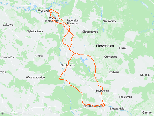
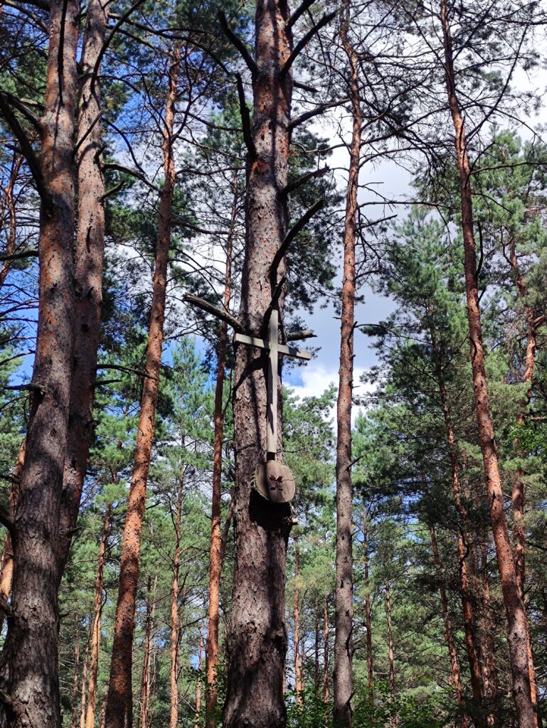
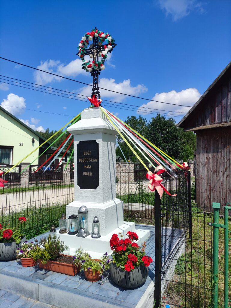
Zdjęcia na trasie
Trasa
| Podział | Dystans (km) | Czas trwania (min) | Różnica wysokości (m) | Średnia prędkość (m/s) |
|---|---|---|---|---|
| 1 | 1.03 | 2:38 | -3.8 | 7.49 |
| 2 | 0.97 | 1:6 | -1 | 10.09 |
| 3 | 1.01 | 1:87 | 5.8 | 8.98 |
| 4 | 1.01 | 2:38 | 25.2 | 7.08 |
| 5 | 0.99 | 1:63 | -12 | 10.1 |
| 6 | 1.02 | 2:02 | 10 | 8.46 |
| 7 | 1.01 | 1:53 | -20 | 11.02 |
| 8 | 0.98 | 2:28 | 12.8 | 7.69 |
| 9 | 0.98 | 1:6 | -6.2 | 10.19 |
| 10 | 1.05 | 1:73 | 8.4 | 10.1 |
| 11 | 1.00 | 1:78 | 12.4 | 9.38 |
| 12 | 0.96 | 2:03 | 6 | 7.89 |
| 13 | 0.99 | 1:62 | -8.4 | 10.21 |
| 14 | 1.01 | 1:75 | 0.4 | 9.63 |
| 15 | 1.01 | 1:45 | -7.4 | 11.65 |
| 16 | 1.04 | 1:7 | 3.6 | 10.15 |
| 17 | 0.93 | 1:6 | 9.8 | 9.69 |
| 18 | 1.02 | 1:88 | -9.2 | 9.03 |
| 19 | 0.97 | 1:8 | -19.8 | 9.02 |
| 20 | 1.01 | 27:97 | -3.8 | 4.36 |
| 21 | 1.00 | 7:42 | 4 | 3.62 |
| 22 | 1.02 | 4:9 | -4.4 | 3.85 |
| 23 | 0.97 | 4:2 | 1.6 | 3.85 |
| 24 | 1.01 | 4:75 | 7 | 3.82 |
| 25 | 1.01 | 4:32 | 11 | 3.9 |
| 26 | 0.99 | 3:88 | 1.6 | 4.27 |
| 27 | 1.00 | 4:57 | 5.2 | 3.66 |
| 28 | 1.00 | 6:8 | -1.6 | 2.5 |
| 29 | 0.99 | 9:08 | -1.6 | 2.98 |
| 30 | 1.02 | 7:15 | 2.4 | 2.88 |
| 31 | 1.01 | 4:57 | -8.8 | 3.68 |
| 32 | 0.98 | 3:57 | -2.8 | 4.56 |
| 33 | 1.02 | 5:08 | 2.2 | 3.35 |
| 34 | 1.00 | 10:23 | -7.6 | 3.19 |
| 35 | 1.01 | 4:12 | 11.4 | 4.2 |
| 36 | 0.99 | 4:85 | 11.2 | 3.57 |
| 37 | 0.99 | 4:65 | -6.2 | 3.53 |
| 38 | 1.00 | 3:8 | -6.4 | 4.4 |
| 39 | 0.99 | 2:93 | -13.6 | 5.64 |
| 40 | 1.03 | 3:43 | -2.6 | 5 |
| 41 | 0.97 | 3:35 | 4.2 | 4.83 |
| 42 | 1.01 | 2:87 | -3.8 | 5.85 |
| 43 | 1.01 | 3:08 | 29.4 | 5.44 |
| 44 | 0.99 | 3:02 | -11.8 | 5.49 |
| 45 | 1.02 | 3:03 | -18.6 | 5.59 |
| 46 | 1.00 | 3:07 | -5.4 | 5.41 |
| 47 | 1.00 | 3:13 | 0.4 | 5.3 |
| 48 | 1.01 | 3:52 | -1.2 | 4.78 |
| 49 | 0.97 | 4:18 | -2.6 | 3.88 |
| 50 | 1.03 | 4:95 | 0.8 | 3.46 |
| 51 | 0.97 | 3:93 | 1.4 | 4.12 |
| 52 | 1.03 | 3:55 | 4.6 | 4.83 |
| 53 | 0.98 | 3:38 | 4.4 | 4.83 |
| 54 | 0.50 | 1:52 | 2.2 | 5.86 |
Miejscowości
- województwo świętokrzyskie
- powiat kielecki
- gmina Pierzchnica
- Brody
- Maleszowa
- gmina Morawica
- Zaborze
- Lisów
- Łabędziów
- Morawica
- Wola Morawicka
- Radomice
- Brudzów
- gmina Chmielnik
- Suliszów
- Grabowiec
- Piotrkowice
- Chmielnik
- Suchowola
- Ługi
- Przededworze
- Jasień
- gmina Pierzchnica
- powiat kielecki
Strava segmenty
| Nazwa | Czas trwania (s) | Czas w ruchu (s) | Odległość (m) | Średnie nachylenie (%) | Maksymalne nachylenie (%) | Wysokość maks. | Wysokość min. |
|---|---|---|---|---|---|---|---|
| Brudzów górka | 139 | 139 | 1086 | 2.5 | 6.9 | 258.7 | 232 |
| Brudziow Maly - Zaborze | 87 | 87 | 700 | 3.5 | 9 | 264.4 | 239.8 |
| Zalesie (Pod Stawami) | 268 | 268 | 1392.4 | -0.4 | 2.4 | 228.8 | 223.6 |
| Brudzów Podjazd zachodni | 249 | 249 | 1412.4 | 1.7 | 15.3 | 269.8 | 238 |
| Brudzów hopka | 47 | 47 | 285.9 | 2.7 | 9.9 | 265.8 | 256.3 |
| TEXAS | 145 | 145 | 777.3 | -0.7 | 0.4 | 237.3 | 231.9 |
| Odwrotny zalew | 282 | 282 | 1006.7 | 0.1 | 1.3 | 229.3 | 228.3 |
Punkty GPS na trasie
Wszystkie: 1560Uproszczone: 218