01.09.2024 13:12
Ride
-
Dystans
56.09 km
-
Średnia prędkość
20.57 km/h
-
Maksymalna prędkość
46.71 km/h
-
Czas ruchu
02:43
-
Całkowity czas
03:45
-
Najniższa wysokość
232.4 m
-
Najwyższa wysokość
320.8 m
-
Suma przewyższeń
360 m
-
Kalorie
1846
-
Kwadraty
37
-
Osiągnięcia
5

Trasa
| Podział | Dystans (km) | Czas trwania (min) | Różnica wysokości (m) | Średnia prędkość (m/s) |
|---|---|---|---|---|
| 1 | 1.05 | 3:83 | -7.2 | 5.93 |
| 2 | 0.98 | 2:47 | -2.6 | 6.61 |
| 3 | 0.98 | 3:22 | 5.6 | 5.08 |
| 4 | 1.02 | 2:15 | -0.6 | 7.91 |
| 5 | 0.99 | 2:47 | 5 | 6.72 |
| 6 | 1.02 | 2:52 | 9.2 | 6.72 |
| 7 | 0.98 | 2:68 | 14.4 | 6.1 |
| 8 | 1.00 | 2:25 | -1.2 | 7.42 |
| 9 | 0.98 | 2:25 | 5.6 | 7.28 |
| 10 | 1.03 | 2:47 | 6.8 | 6.97 |
| 11 | 1.00 | 2:63 | -3.2 | 6.35 |
| 12 | 0.98 | 2:02 | -15.2 | 8.08 |
| 13 | 1.01 | 3:58 | 17.2 | 4.68 |
| 14 | 1.01 | 2:77 | -3.6 | 6.09 |
| 15 | 0.98 | 5:38 | 2 | 3.9 |
| 16 | 1.01 | 3:65 | -6 | 5.65 |
| 17 | 1.00 | 2:98 | 3 | 6.27 |
| 18 | 1.03 | 2:48 | -2.4 | 7.61 |
| 19 | 0.98 | 1:93 | 0.8 | 8.41 |
| 20 | 0.98 | 2:37 | -2.6 | 6.88 |
| 21 | 0.99 | 3:02 | 9.2 | 6.57 |
| 22 | 1.00 | 2:72 | 1.6 | 6.39 |
| 23 | 1.03 | 3:57 | -4.6 | 5.02 |
| 24 | 0.98 | 3:15 | 4.4 | 6.07 |
| 25 | 1.00 | 4:02 | 8.4 | 5.37 |
| 26 | 1.01 | 2:1 | -2.2 | 7.98 |
| 27 | 0.99 | 2:23 | 1 | 7.38 |
| 28 | 1.02 | 2:5 | 4.2 | 6.79 |
| 29 | 0.99 | 4:97 | 8.8 | 6.06 |
| 30 | 1.01 | 3:87 | 8.6 | 4.76 |
| 31 | 0.98 | 3:83 | 6.6 | 4.25 |
| 32 | 1.06 | 3:8 | -7.6 | 5.5 |
| 33 | 0.96 | 4:42 | -16 | 4.57 |
| 34 | 0.99 | 5 | 15 | 3.71 |
| 35 | 1.01 | 4 | -8.4 | 6.13 |
| 36 | 1.00 | 3:08 | 7.6 | 6.51 |
| 37 | 1.01 | 3:82 | 16.2 | 4.99 |
| 38 | 1.00 | 3:92 | -20.6 | 6.92 |
| 39 | 1.04 | 2:97 | -15.6 | 5.84 |
| 40 | 1.01 | 2:35 | -3 | 7.16 |
| 41 | 0.95 | 1:72 | -6.6 | 9.2 |
| 42 | 0.98 | 1:95 | -10.2 | 8.42 |
| 43 | 1.05 | 2:3 | 5.6 | 7.6 |
| 44 | 0.98 | 1:95 | -9.2 | 8.35 |
| 45 | 0.98 | 3:03 | 22 | 5.36 |
| 46 | 1.00 | 2:45 | -7.4 | 6.84 |
| 47 | 1.05 | 2:72 | 4.4 | 6.45 |
| 48 | 1.01 | 1:82 | -24.6 | 9.25 |
| 49 | 0.96 | 2:05 | -4 | 7.84 |
| 50 | 1.01 | 2:23 | 1 | 7.53 |
| 51 | 0.99 | 2:45 | -1.6 | 6.74 |
| 52 | 0.97 | 2:35 | -4.4 | 6.9 |
| 53 | 0.99 | 44:07 | -0.2 | 5.96 |
| 54 | 1.01 | 8:25 | 0.8 | 2.66 |
| 55 | 1.00 | 4:68 | 0.2 | 3.54 |
| 56 | 1.00 | 14:95 | 9.4 | 3.98 |
| 57 | 0.09 | 0:68 | 2.2 | 2.64 |
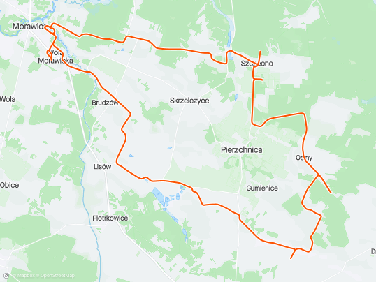
Miejscowości
- województwo świętokrzyskie
- powiat kielecki
- gmina Morawica
- Zaborze
- Lisów
- Łabędziów
- Morawica
- Wola Morawicka
- Radomice
- Brudzów
- gmina Daleszyce
- Komórki
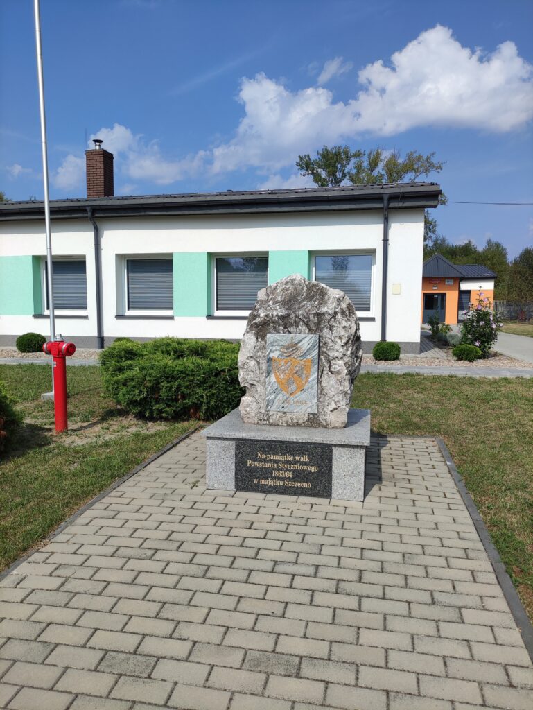
- Szczecno
- gmina Pierzchnica
- Skrzelczyce
- Czarna
- Strojnów
- Brody
- Maleszowa
- Pierzchnianka
- Osiny
- Gumienice
- gmina Morawica
- powiat kielecki
Strava segmenty
| Nazwa | Czas trwania (s) | Czas w ruchu (s) | Odległość (m) | Średnie nachylenie (%) | Maksymalne nachylenie (%) | Wysokość maks. | Wysokość min. |
|---|---|---|---|---|---|---|---|
| [R] Morawica - Łabędziów | 171 | 171 | 1319.8 | 0.2 | 2.9 | 213 | 208.2 |
| Łabędziów-Komórki podjazd | 1069 | 1069 | 7345.1 | 0.6 | 5.4 | 272.4 | 229 |
| Radomice Las | 293 | 293 | 1986.1 | 0.7 | 7.2 | 249.8 | 236 |
| Radomice Drugie / Zagórze, Główna (św. Antoniego - Skok) | 103 | 103 | 760 | -0.1 | 0.9 | 260.9 | 260.2 |
| Szczecno Uphill | 227 | 227 | 1100.8 | 0.9 | 7.2 | 267.9 | 252.1 |
| Lisów, Pod Stawami - Zaborze pod górę | 174 | 174 | 970 | 2 | 4.3 | 261.4 | 241.5 |
| Brudzów zjazd do Podemłynia | 181 | 181 | 1548.2 | -2 | 0 | 276.2 | 245.6 |
| Odwrotny zalew | 2927 | 345 | 1006.7 | 0.1 | 1.3 | 229.3 | 228.3 |
Punkty GPS na trasie
Wszystkie: 1507Uproszczone: 238